
Hurricane Matthew was on the news this last few days and as it was moving through the Caribbean with deadly effect, Florida Governor Rick Scott was already warning residents of the state that they needed to leave the low-lying areas in the eastern parts of the state. If people didn’t leave, he said, “This storm will kill you. It’s a monster, get out.”
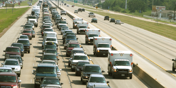
Governor Scott was not alone in his scary warnings. In South Carolina, Governor Nikki Haley was also advising residents to leave low-lying areas. “This is a storm we want to take seriously,” she said, “There is nothing safe about what is getting ready to happen,” she said urging residents to evacuate. Later, news photos showed all lanes on Interstate highways leaving South Carolina’s coastal areas filled with cars. Recent similar events were still in people’s mind and it seemed the message was listen.
Still this kind of procedure is very complexe and hard to manage and the big question is always how complete the evacuation was. There is always eople who refuse to leave an evacuated area causing significant problems for themselves and for the first responders who have to stay behind.
Obviously, such conduct may result in people dying. Bust most of the time, those people will find that they underestimated the fury of the storm, and will demand to be rescued. This scenario happens in every major storm, and the onslaught of Hurricane Matthew was no exception. However, even if you can’t force everyone to leave an area, it at least helps to have a precise idea on how many people stayed behind, and approximately where they are.
This is the issue addressed by Mogean Inc. The company uses location services data from mobile phones to develop geolocation data and produce predictive analytics that can provide products and services to consumers. But when the hurricane started to crush its way toward the United States, Mogean’s executives decided to put the location data they were collecting to use in helping with the emergency units. The task they gave themselves was to determine what areas under evacuation orders were actually evacuated, and which were not. As the storm grew closer, Mogean’s staff started to identify patterns. Some areas in Florida and South Carolina were making good progress in evacuating their citizens, but some were not. Access to this precious data by state leaders, would be a great help to find out where to concentrate their efforts and where their efforts were already working.
“We can create a bread crumb trail from mobile apps,” Mogean co-founder and Chief Operating Officer Reid Maulsby said. He explained that they were able to get the location data from those mobile apps, which include a wide variety of sports and entertainment apps on iOS and Android cell phones, and use that data to determine where and when people were moving. Conscious of privacy issues, it also stated that Mogean receives no personal information but the company’s data sets can still tell where people go. “We can identify where people spend time, where they work and live. We can compare that with data from the National Weather Service and information on mandatory evacuations.” Maulsby also noticed that the company can only read the data from phone users who have allowed location services on their devices, but he said that this is enough to determine trends and patterns showing how many people are leaving an area and where they’re going.
This analysis of data is proving that it could help in disaster situations, providing emergency units with accurate data to focus efforts on the right areas.
More around this topic...


© HPC Today 2024 - All rights reserved.
Thank you for reading HPC Today.


